A short summary of my hiking experience in NSW, Australia
Geography:
- All towns and villages locate along the main roads and highways. There are no towns or villages every couple of kilometres, that one may found in Europe. Farms and bush covers the area in between the major transport routes.
- One may think Australia is almost flat, because it is the lowest continent. This is very wrong. The landscape is extremely rich in topography features. My typical hike includes 1-1.5 km up and down (each way) for 30 km route.
- Australia offers a great diversity of landscapes even in the range of day trip from Sydney: mangroves in estuaries, rainforests of at least two different types in gullies, dry gum tree (eucalyptus) forests, dune and lagoon vegetation, etc.

Blue Mountains, 100 km to the West from Sydney. Absence of any settlements, difference in elevation is hundreds of metres. The vegetation both atop and below the cliffs is gum tree forest

Rainforests in 50 km from Sydney to the South
Transport:
- Trains runs every 1-2 hours from the most of the stations within 200 km from Sydney (however, I faced several delays by 30+ minutes). It is a comfortable and cheap mean of transport.
- Railways close for maintenance very often. It can happen both on weekdays and on weekends. Replacement buses run regularly for free. Transport marshals (attendants) are supposed to help with navigation, but sometimes they give very wrong clues even about the timetable on the station they serve.
- Town buses can run really out of any timetable due to an incredible number of stops every 100 m (!). One should wave them with a hand to board.
- Intercity buses (coaches) run pretty seldom. For example, a bus from the capital of Australia to the main ski resort just nearby ran once in two days. The reason is the very high number of private cars in Australia.
- Buses depend a lot on traffic jams. I have already faced buses going 30 minutes both before (!) and after the scheduled time.
- A lot of villages has no means of public transport at all. A railway and even a railway station in a village (on a map) does not mean there is any connection.
- Almost all state transport in NSW is available using Opal card (similar to London Oyster or Moscow Troika cards). One can top the balance up at petrol stations and in supermarkets (but not on bus stops, for example!). Their website is pretty convenient.
- All the transport for any number of rides costs only 2.8 AUD on Sundays. It is easy to travel for 200 km from home, make a long hike, and come back on the same date.
- Far distance trains (like Sydney-Brisbane) require ticket booking in advance. There are also (cheap) far-distance private bus companies.
- An interesting option to travel are historic trains, which can deliver you to some unusual place. However, my own personal experience shows, that they can be cancelled just couple of days before the trip.
- Hitchhiking in Australia exists, but this is not a reliable way of travel: almost nobody stops. Notice that it is legally legally prohibited in two AU states!
- There is a number of different private ferries along the coast, such as Cronulla-Bundeena, Brooklyn-Wobby-Dangar, to Patonga, to Ettalong. Cash only.
- Volunteers restore two historical railways: Cooma-Monaro and Zig Zag. These projects use crowdfunding and governmental support. There are some other exotic routes like historic train with solar panels.

A far-distance suburban train

Private ferry
Weather:
- Summers are really extremely hot, up to +45°C [thanks to global warming]. The air is relatively dry (compared to SE Asia countries)
- If a rain starts, it can go for a week almost non-stop. A flood is possible.
- At night temperature goes easily to the values as low as +3°C, especially in winter and even at the coast. Temperature can run below zero in the mountains. The lowest temperature recorded in AU is -23°C.
- Altitude and lateral zoning is very clear. Temperature can be 20°C lower in 100 km away and 100 m higher than the seashore. The feeling is very clear.
- Snow happens. This year there were up to 30 cm of snow at latitude close to Sydney.
- The major issue is the amount of UV radiation here. I strongly recommend to read a WHO brochure and averaged map of solar activity. UVI of 12 is usual for summer. I use here sunscreens with the Cancer Council logo, looks to work well.

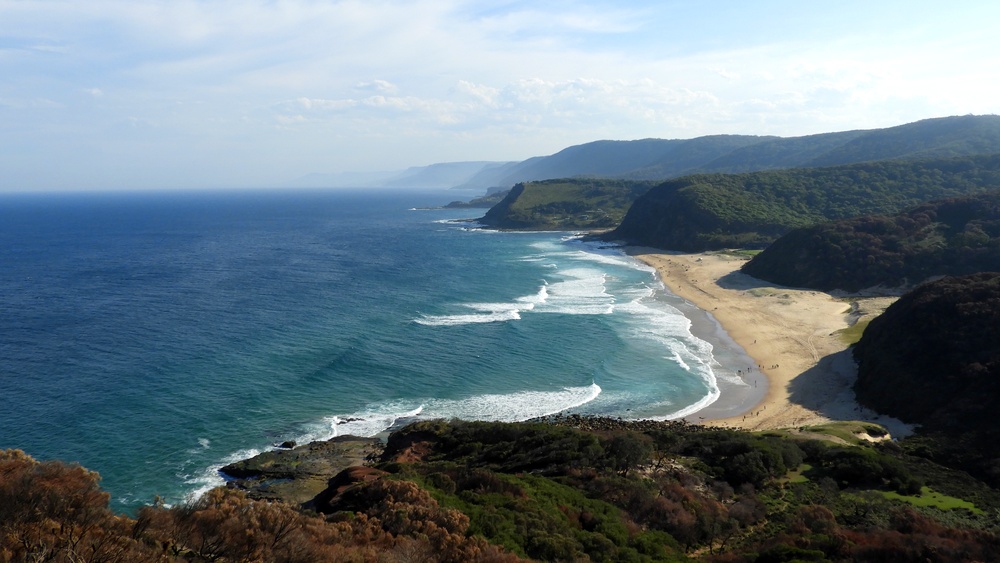
Royal National Park, 20 km from Sydney to the South
Many kilometres with no shadow
Many kilometres with no shadow
Animals and plants:
- I do not like people saying "everything wants to kill you in Australia". Australia is a country with normal amount of different animals, while in all the rest of the countries it was reduced sufficiently due to humans.
- A year and a half were enough for me to meet several deadly or just dangerous snakes, including Eastern brown and Tiger snake. Local snakes do not go away, but remain on trail, so one must be careful. I would recommend hiking poles: in high and dense grass it once helped me to avoid being biten by black red-bellied.
- Spiders. Yes, they are. Don't leave the trail too often.
- Very few mosquitoes. Lots of really annoying flies, but they do not even bite. They do not carry diseases.
- Land leeches wait for your blood. Do not transmit diseases.
- Ticks. There are no registered cases of Encephalitis or Lyme disease in AU. There are some fevers, but they seems to be much lighter.
- Most of the plants are not dangerous if you do not suddenly decide to eat unknown stuff. A lot of nettle! A lot of vines. A lot of plants with spikes! And vines with spikes! They catch you, your clothes, your backpack, everything, everything, just let me go!!!
- Gum trees do not burn or burn very badly. However, they produce a lot of oils and dry flammable material like leaves and bark, which can be ignited by a single thunderbolt. They say, gun trees might even benefit from such a way of undergrowth clearing. An area after a bushfire with black ash and white trunks is known as "blackbutt", which is a relatively common name on maps.
- There are edible mushrooms like saffron milk cap and Suillus mushrooms. I collected, ate, survived. With pleasure.
- If you leave any open food in your tent, you invite termites and ants. Outside the tent there are also possums and magpies. Magpies are generally very interested in your stuff.
- Kangaroos shall not be bullied. It might get very unhealthy. For you.

Eastern brown is the second most venomous land snake

Locals
Camping:
- The land can be roughly divided to three categories: habitated, crown land (federal property), protected areas (National Park, Nature Reserve, etc).
- Camping is allowed more or less anywhere on the crown land (may differ in different parts of AU), however, they recommend to use free campgrounds. There is no or almost no such land close to Sydney: all is either protected or habitated.
- If you decide to camp in habitated area (for example, at the town beach), to pay a fine, starting from 110 AUD. You can try to get an explicit permition from a land owner to camp at the property (no idea how it works)
- There are tons of campings in the habitated area (especially at the sea shore). However, if you need a place "for tomorrow", it might be a tough deal to find any free spot. Recently I looked for a spot, and I had to seek through 50 km of seashore just to find something! The booking required several emails and even phone calls! Many campings require you to pay at least for two nights if you arrive during the weekend.
- National parks offer free and fee-paying campgrounds (both of them might be even without facilities). The fee-paying campgrounds might be booked for months in advance (!) (e.g. weekends in North Era in Royal National Park). Free campgrounds are pretty common, sometimes really perfect places with water, fireplace and a plenty of room for tents.
- European campings often have a lot of food leftovers, including spices and sauces, but here one can find barely nothing.
- A proper tent should allow to stay at temperatures as low as +5°C (and temperature can run below zero in mountains during winter). Seashore has higher temperatures, but wind gusts can reach 65 km/h. A tent with skirt might be a reasonable option.
Other facilities:
- Many popular touristic places offer a variety of facilities, such as bbq stoves, potable water, WCs. But there might be no trash bins, obviously to deter wild animals.
- Generally, water from creeks is not recommended for drinking even after boiling. The reason for this is presence of wastes from agriculture and settlements (however, there are tons of crayfishes even in such streams). I would like just to remind that health organisations recommend at least 1-2 minutes of boiling.
- Fire. There are three major cases: absence of fire ban (you are allowed to make a campfire using firewood - look for an existing campsite!); fire ban, when you can use only gas stoves and some other stuff; total fire ban, when you may not use almost any fire at all.
- Shops, vending machines, cafes might be totally absent even on the most popular touristic destinations.

Royal National Park, 30 km to the South from Sydney
After bushfire
After bushfire
Hiking trails:
- There is no state-wide NSW colour scheme to mark the difficulty of bushwalking trail. There are some textual descriptions like "medium to hard grade". I recommend to always read NSW National Park service website and numerous blogs and forums to get description of local places.
- There are some websites offering maps with coloured trails. There are also lists of hiking routes between public transport stations.
- I try to download GPS-tracks for new routes from forums. Generally, it is not a big deal to find one in open access.
- Many trails are not very well marked on terrain (colour spots on trees/stones etc). Sometimes it is pretty easy to loose the trail on rocks and in twilight.
- Due to massive vegetation, hiking trails are not seen on satellites. However, some free online maps store the tracks with extremely good precision.
- One may clearly see on satellite images dirt (unsealed) roads, called fire trails.
- I would point out that gum tree forests are very dry, so a plenty of people experience breathing problems here. Also a plenty of people are very allergic to local pollen.
- Visiting karst caves in National Parks is prohibited [however, caving clubs manage to get a permission]. Still one may visit sea caves, abandoned mines, wind caves and other underground stuff without need to get a permission.
- Some places on the seashore are completely not accessible during high tide.
- Bikes are allowed on highways, and locals drive very calmly and accurately.

Blue Mountains, 100 km to the West from Sydney. A typical fire trail
Royal National Park, 40 km to the South from Sydney
One can get here only during low tide
One can get here only during low tide

Blue Mountains, 100 km to the West from Sydney.
A typical forest. Speed off-track tends to zero
SOS and networks:
- National park administration encourages to give a notice about tough hikes. They can provide for free (with a deposit) GPS-beacons to call for rescue. Probably, it is good idea to check whether this will be covered with medical insurance.
- Mobile network covers almost only habitated areas. Even in between adjacent railway stations close to Sydney there might be no signal at all. GPS may work bad in forests in canyons.
- Sim-card might be easily bought in a supermarket with further online registration. If one wants a prepaid card, here there are very few options for a real prepaid card: most of the operators offer plans, which zeroes money in a month.
- Very friendly. One of the most friendly people I've ever met after visiting 50+ countries.
- It is disappointing to hear too often a phrase: "oh, this is only from the end of XVIII - mid of XIX century, you have much older stuff in Europe". I always answer that in Russia the predominant most of architectural heritage has similar age.
Laws and further information:
- Australia is the country of bush fires. A few weeks ago more than 1 000 000 ha of forest were in fire. Therefore, there won't be any mercy to tourists making an illicit campfire. Penalties start from 2200 AUD and might and up with jail and compensations to all the victims if you triggered a bushfire.
- An online map with actual fires runs in real time.
- Local weather bureau gives detailed forecasts.
- Some parts of parks might be closed for entrance due to the risk of fire. Again, check the NSW National Parks service website before hiking.
- A more detailed document on where to camp.
- Rules of behaviour in National Parks - must be obeyed by everybody.
- The park entrance fee listed everywhere is only for cars. Hikers enter for free.
- Smoking in National Parks is absolutely prohibited. It is also prohibited on railway stations and might be prohibited on streets in town centres.
- Alcohol is allowed. One should keep in mind that most of supermarkets have no license to sell alcohol and therefore offer alcohol-free wine and beer. Alcohol supermarkets offer a great variety of nice and cheap wine.

Комментариев нет:
Отправить комментарий